Templot Club Archive 2007-2020
|
|||
| author | remove search highlighting | ||
|---|---|---|---|
|
posted: 21 Jan 2016 17:23 from: tarik
click the date to link to this post click member name to view archived images |
Hi, I'm new to the forum but have been a user of Templot for a while now. I wish to create a layout at home using a real world trackplan. I've created and imported a trackplan as a background shape and wish to overlay the track templates but the templates are way too large for the background and when I zoom into the picture I lose the definition! Am I missing something simple? Any help would he gratefully received. Regards Tarik |
||
|
posted: 21 Jan 2016 18:50 from: Martin Wynne
click the date to link to this post click member name to view archived images |
Hi Tarik, Welcome to Templot Club.  For some notes on importing scanned images as background picture shapes, see this recent topic: topic 2825 If the image becomes blocky or fuzzy when scaled up to match the track templates, you need to scan it again at a higher dpi resolution on the scanner. If you post the image here as an attachment, it will be easier to suggest a solution. regards, Martin. |
||
|
posted: 21 Jan 2016 19:21 from: tarik
click the date to link to this post click member name to view archived images |
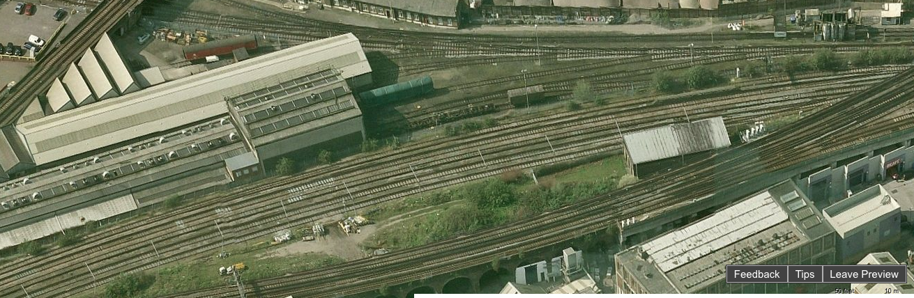
Martin Wynne wrote:Hi Tarik, Hi Martin, Thank you for your reply. I fear I cannot increase the resolution of the image as I lifted it form google maps and then stitched it together in Photoshop. However, I have attached part of the plan below just in case there is a solution. Regards, Tarik |
||
| Attachment: attach_2217_2830_test_image.png 351 | |||
|
posted: 23 Jan 2016 18:12 from: Tony W
click the date to link to this post click member name to view archived images |
Hi Tarik. What scale are you working in as this will determine how much the background picture needs to be enlarged? At the resolution of this picture you are not going to get great definition whatever you try, but we can at least get the scale correct. Tony W. |
||
|
posted: 23 Jan 2016 18:20 from: tarik
click the date to link to this post click member name to view archived images |
Hi Tony, I'm working in 4mm scale. I am also searching for a higher res image which hopefully will help. Regards Tarik |
||
|
posted: 23 Jan 2016 19:28 from: Martin Wynne
click the date to link to this post click member name to view archived images |
Hi Tarik, Where is this location? If in London, the NLS have some very detailed historical maps available. These won't show modern tracks, but they do show general alignments, viaducts, tunnels, etc. e.g. 2_041138_380000000.png  See this topic: topic 2328 For modern tracks you can almost always find the OS large scale maps online, usually small areas, from which you can paste together a larger map (or use multiple picture shapes in Templot). For example my local County Council has a map online showing the locations of winter road grit bins for residents' use. And when you zoom in to the maximum extent, suddenly you get this: 2_231403_440000000.png  Worcester Tunnel Junction. Here's a direct link to the above map: http://gis.worcestershire.gov.uk/WccGISOnline/maps.aspx?xmin=385816&ymin=255770&xmax=385929&ymax=255825&l=40#top These are fine as Templot backgrounds. For example this turnout is found to be a D-10: 2_231419_130000000.png  The switch toe marks are very faint, but are there (ringed red above). Align this to the blade tip marks in Templot. These images are infringing OS copyright, so I will leave them up only long enough for you to get the idea. Otherwise it is off to the tower for me. For more info about fitting track to background maps, see: http://templot.com/companion/index.html?swell_function_ctrl_f10.htm regards, Martin. |
||
|
posted: 23 Jan 2016 19:48 from: tarik
click the date to link to this post click member name to view archived images |
Wow, that's fantastic Martin! I think that's the way forward for me. The area I am trying to model is Stewarts Lane depot in Battersea. Thanks all for your help...off to do some searching now. Kind regards Tarik |
||
|
posted: 23 Jan 2016 21:35 from: Tony W
click the date to link to this post click member name to view archived images |
Hi Tarik. That would certainly be your best approach. I have played around with your picture and it is very difficult to scale accurately. The only known reference is the length of the electro-diesel at 50 ft over body. However due to the angle of the picture, the depth is somewhat foreshortened relative to the width. I will attach what I have done (3 files) and you will see the limitations. Regards Tony W. |
||
| Attachment: attach_2218_2830_Test_file.box 235 | |||
|
posted: 23 Jan 2016 21:36 from: Tony W
click the date to link to this post click member name to view archived images |
File 2 |
||
| Attachment: attach_2219_2830_Test_file.bgs 247 | |||
|
posted: 23 Jan 2016 21:38 from: Tony W
click the date to link to this post click member name to view archived images |
File 3 Put the .bgs and .sk81 files in the shapes folder and the .box file in the box folder before you try them. Regards Tony W. |
||
| Attachment: attach_2220_2830_Test_file.sk81 259 | |||
|
posted: 24 Jan 2016 08:41 from: tarik
click the date to link to this post click member name to view archived images |
Hi Tony, Thanks for the files and your help - it's very much appreciated. I'll have play shortly and let you know! Kind regards Tarik |
||
|
posted: 31 Jul 2016 18:07 from: rodney_hills
click the date to link to this post click member name to view archived images |
Tarriq further to the hints by Martin W, this may be of some use http://svsfilm.com/nineelms/email.htm quote 15th May 2015: George Prot has asked: I wonder if you can help/ point me in the right direction of obtaining a copy of the track plan of Stewarts Lane (Battersea) depot. Any help and advice will be greatly appreciated. 31st May 2015 Adrian Daffern has replied: George Prot can find the track plan for Stewarts Lane is available in 'An Historical Survey of Southern Sheds' by Chris Hawkins and George Reeve. Copies available from Amazon. Also http://www.old-maps.co.uk can be helpful. Regards, Rodney Hills |
||
| Last edited on 31 Jul 2016 18:09 by rodney_hills |
|||
|
posted: 13 Sep 2016 05:46 from: Martin Wynne
click the date to link to this post click member name to view archived images |
Martin Wynne wrote: For modern tracks you can almost always find the OS large scale maps online, usually small areas, from which you can paste together a larger map (or use multiple picture shapes in Templot). The Boundary Commission have just posted maps of their proposed electoral changes for the whole of the UK: http://www.bce2018.org.uk If you zoom in as far as it will go, you get detailed mapping of modern railway tracks. Not quite as detailed as the "grit bins" mapping which I posted earlier in this topic but still very useful for Templot design backgrounds. This is the Severn Valley Railway's turntable at Kidderminster: 2_130037_480000000.png  And here is the same on the County Council's grit-bin map. A smaller zoom but it does have finer detail and the advantage for our purposes of showing (very faintly) the switch toes (and also the set of catch points in the siding): 2_130040_290000000.png  regards, Martin. |
||
|
posted: 14 Sep 2016 11:56 from: philchudley click the date to link to this post click member name to view archived images |
Another resource I find useful is the side by side maps OS 25" compared with Bing Satellite http://maps.nls.uk as shown below: 672_140656_090000000.jpg  There are a number of other map resources here as well. Not the entire country at the moment, but very interesting to compare earlier dates with today. Phil |
||
| Last edited on 14 Sep 2016 12:03 by philchudley |
|||
|
posted: 14 Sep 2016 15:19 from: Martin Wynne
click the date to link to this post click member name to view archived images |
Hi Phil, Thanks. Yes, we have mentioned the NLS 25" maps before. They are currently moving northwards across the whole of England and Wales and are currently about half-way through the project. Unlike the old-maps.co.uk site, it is all free and without watermarks. Also the scanning resolution seems to be better, which is significant when zooming in on them for use in Templot. In addition to the side-by-side option, the scans are being integrated into their seamless geo-referenced system. You can cross-fade from historic to present-day mapping or aerial views, making a wonderful resource for track planning and scaling. See this bit of video which I made a few months ago: http://flashbackconnect.com/Default.aspx?id=8Du_Kizucpvgbsfe2rGw4g2 regards, Martin. |
||

| Please read this important note about copyright: Unless stated otherwise, all the files submitted to this web site are copyright and the property of the respective contributor. You are welcome to use them for your own personal non-commercial purposes, and in your messages on this web site. If you want to publish any of this material elsewhere or use it commercially, you must first obtain the owner's permission to do so. |