 Search
Martin Wynne
Admin
- Location
- West of the Severn UK
- Info
- .
Enjoy using Templot?
 Thanks.
Please do not send requests for help direct to me via email.
Post your questions on the forum where everyone can see them and add
helpful replies.
.
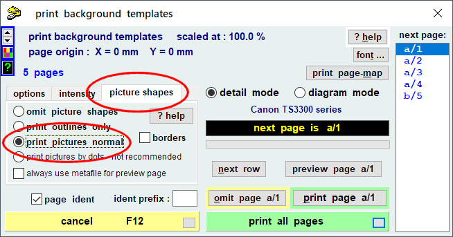
If you are printing a background map behind your track templates, there is something to bear in mind.
Using the map as originally captured from the NLS web site, it might look like this:

That would be printing the off-white background across the entire page, using a lot of ink and maybe causing the paper to cockle. Also it will be difficult to see the rail edges against the magnified dark map detail.
It's worth using the map clarity functions to improve the printed result -- but take care with the settings because you could easily make matters a lot worse with a dark background across the entire page!

Use the 2-tone reduction function, and be sure to set the high colour to white. Click the change button to set it.
Also set the low colour to a mid-to-light grey colour.
The threshold setting will need some trial and error according to the actual map, but a setting around 180 will usually be a good starting point. Lower settings tend to lose some of the detail. Higher settings cause the detail to clog up. (Too low is better than too high.)
The result should look something like this:

which when printed will look like this:

You can see that the rail edges are still not very easy to see, and I could have used a much lighter grey for the low colour without losing any wanted detail, such as the outline of the cattle pen or signal box. Or if you have plenty of colour ink you could set a bright colour instead of grey for the low colour, to contrast against the black rail edges.
For details of how to include maps in the printed templates, see this post:
https://85a.uk/templot/club/index.php?threads/maps.348/post-3308
For more about capturing historic maps and using the map clarity functions, watch this video:
https://85a.uk/templot/companion/get_map_from_the_web.php
• The above map is at Witton, Birmingham. A wayside LNWR goods yard "Witton Wharf":
https://maps.nls.uk/geo/explore/#zoom=19&lat=52.51357&lon=-1.88865&layers=117746211&b=4
This is one of the excellent 125" Town Plans series from the NLS. Unfortunately they are available only for large urban areas, and only for early pre-grouping days -- this is the 1886 survey. Notice the common pre-grouping practice of using a short switch even in a long turnout. This appears to be a 9ft switch in a 1:10 turnout, which would be regarded as a strange turnout size nowadays. 1954 picture of this location:
https://www.warwickshirerailways.com/lms/lnwr_wit2297.htm
cheers,
Martin.
More tips of the day: https://85a.uk/templot/club/index.php?forums/tips-of-the-day.44/
If you are printing a background map behind your track templates, there is something to bear in mind.
Using the map as originally captured from the NLS web site, it might look like this:
That would be printing the off-white background across the entire page, using a lot of ink and maybe causing the paper to cockle. Also it will be difficult to see the rail edges against the magnified dark map detail.
It's worth using the map clarity functions to improve the printed result -- but take care with the settings because you could easily make matters a lot worse with a dark background across the entire page!
Use the 2-tone reduction function, and be sure to set the high colour to white. Click the change button to set it.
Also set the low colour to a mid-to-light grey colour.
The threshold setting will need some trial and error according to the actual map, but a setting around 180 will usually be a good starting point. Lower settings tend to lose some of the detail. Higher settings cause the detail to clog up. (Too low is better than too high.)
The result should look something like this:
which when printed will look like this:
You can see that the rail edges are still not very easy to see, and I could have used a much lighter grey for the low colour without losing any wanted detail, such as the outline of the cattle pen or signal box. Or if you have plenty of colour ink you could set a bright colour instead of grey for the low colour, to contrast against the black rail edges.
For details of how to include maps in the printed templates, see this post:
https://85a.uk/templot/club/index.php?threads/maps.348/post-3308
For more about capturing historic maps and using the map clarity functions, watch this video:
https://85a.uk/templot/companion/get_map_from_the_web.php
• The above map is at Witton, Birmingham. A wayside LNWR goods yard "Witton Wharf":
https://maps.nls.uk/geo/explore/#zoom=19&lat=52.51357&lon=-1.88865&layers=117746211&b=4
This is one of the excellent 125" Town Plans series from the NLS. Unfortunately they are available only for large urban areas, and only for early pre-grouping days -- this is the 1886 survey. Notice the common pre-grouping practice of using a short switch even in a long turnout. This appears to be a 9ft switch in a 1:10 turnout, which would be regarded as a strange turnout size nowadays. 1954 picture of this location:
https://www.warwickshirerailways.com/lms/lnwr_wit2297.htm
cheers,
Martin.
More tips of the day: https://85a.uk/templot/club/index.php?forums/tips-of-the-day.44/
message ref: 4467