 Search
Cransford
Member
- Location
- New Southgate
Firstly, thought something very odd had happened when I couldn't find previous thread on half scissor/outside slip for an Oxenholme thought, didn't realise you'd 'opened new premises'!
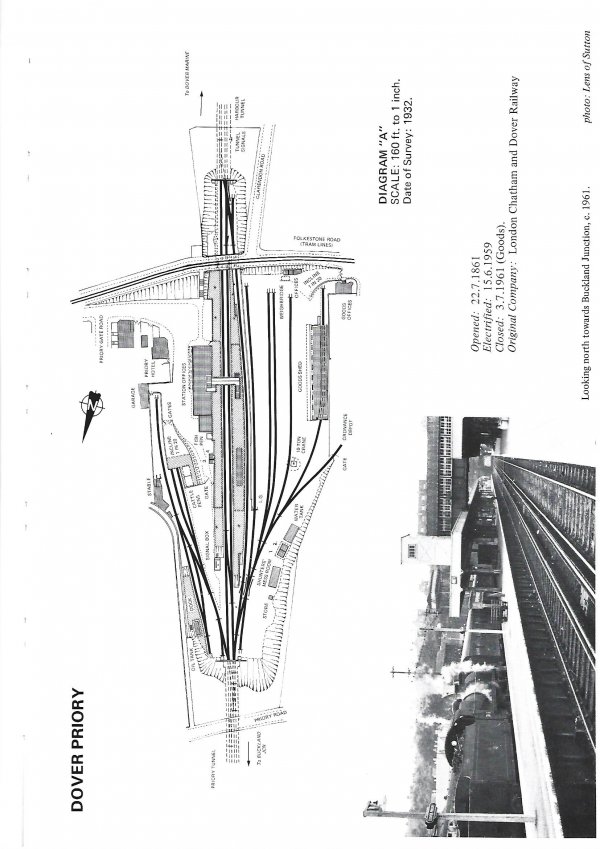
Whilst Oxenholme is a thought on 2mm, another thought has landed for a P4 layout based on Dover Priory just as electrification landed [my dream shed has been given royal planning consent!]. It was spurred by an article in Back Track that included a plan of the 1930's SR proposed remodelling. As NLS only had an earlier OS map, I used that and some photographs to 'estimate' the new layout. Obviously, a newer map/drawing would be better, and I've found one in an OPC book on Southern Stations! Interestingly it shows numerous differences between what was planned and what actually happened, so much so that I wanted to use it for a redraft. Finally, we arrive at the question (apologies!);
I scanned the book page at native resolution on an HP2700 printer/scanner (don't ask what dpi setting is as I can't find it anywhere!!) and saved as a jpeg [copy attached]. Via background menu, imported onto track plan and tried to resize to suit P4 gauge. Failed dismally as I measured the layout plan based on NLS map to confirm distance between tunnel is 3660mm (or 915 real feet). I tried to resize dragging mouse to give 120+% enlargement but when saved it merely reloads at original size. Also, the opening templates are frozen (will not move, rotate, etc). I recall this as an issue when loading maps and there was a way but doesn't seem to be one for a scan?
Note, edited in red to correct the distance between tunnels, me bad!!
For added interest, the original drawing has scale of 160feet to 1 inch and that equates to 1:1920.
Looking at the planning work ahead, the S&C in :London end tunnels seems to be fun - under done scissors with slip!
As always, your timely help would be most welcomed.
Attachments
message ref: 184
Last edited: