Templot Club Archive 2007-2020
|
|||
| author | remove search highlighting | ||
|---|---|---|---|
|
posted: 3 Feb 2018 11:03 from: Hayfield
click the date to link to this post click member name to view archived images |
I am about to embark on building my new layout, loosely based on Bodmin General in preservation era. My question is, approximately how far apart should the runaround road be from the platform road please, as I plan to fit the water standpipes between the tracks, I am guessing it should be a bit more than the usual preset distances within Templot Thanks John |
||
|
posted: 3 Feb 2018 11:51 from: Martin Wynne
click the date to link to this post click member name to view archived images |
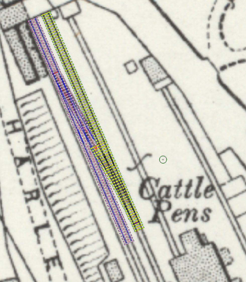
Hayfield wrote: I am about to embark on building my new layout, loosely based on Bodmin General in preservation era. My question is, approximately how far apart should the runaround road be from the platform road please, as I plan to fit the water standpipes between the tracks, I am guessing it should be a bit more than the usual preset distances within Templot.Hi John, Yes, it is often a bit wider. Overlaying on the OS map from 1905 shows at that time it was around 7ft way, i.e. 1ft wider than the minimum 6ft way. See: 2_030637_390000000.png  To match that, set the TS spacing to 146" instead of the usual 134", i.e. 12" wider. Of course, it may have changed in over 100 years. If you need a bit more space for items between the tracks you could add more than that, say 18" or 24" extra ( = 152" or 158"). If modelling the present-day preservation the only way to be sure is to go and measure it. The turnouts turned out to be 1:8 as usual, but will have moved since then (for a longer loco clearance at the end). cheers, Martin. |
||
|
posted: 3 Feb 2018 17:13 from: Hayfield
click the date to link to this post click member name to view archived images |
Martin Thank you very much, an educated guess is the track bed is much the same, also I am modelling it very loosley on how it is today. So the track plan will be similar, but altered to my requirements. Sightly compressed in length. Using commercially available building kits altered to give the flavour of the station, perhaps keeping the goods shed. Sort of how it might have developed, rather than a slavish representation I wish I knew not only how to import these maps into Templot, but also how to get it to the correct size. As far as I am concerned a total black art. When ever I try with scanned maps the enlargements tend to be out of focus etc Thanks again, much appreciated |
||
|
posted: 3 Feb 2018 17:32 from: Tony W
click the date to link to this post click member name to view archived images |
Martin Wynne wrote: The turnouts turned out to be 1:8 as usual, but will have moved since then (for a longer loco clearance at the end).The GWR also had the same problem as the platform road release was extended at some time by cutting back into the platform several feet. Regards Tony. |
||
|
posted: 3 Feb 2018 17:53 from: Martin Wynne
click the date to link to this post click member name to view archived images |
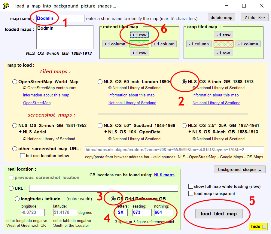
Hayfield wrote: I wish I knew not only how to import these maps into Templot, but also how to get it to the correct size. As far as I am concerned a total black art.Hi John, You haven't been paying attention at the back. Nowadays Templot does all that for you. If you can manage with the 6"/mile map (available for the whole country) it's dead easy because I have paid a subs to the NLS to get that map as a tiled map. That means you can get more and more rows and columns of map tiles until you have the entire area you want, or more. You just need to know the OS grid reference to get started. Templot does the rest. For Bodmin the OS grid reference is SX 073 664 For all this go to the background > maps menu item: 2_031310_060000000.png  The 6" map is fine for overall dimensions, buildings, bridges, etc. Templot does all the scaling for you provided you have set your gauge/scale first. For detailed track planning however, at least 25"/mile is needed. For the 25" maps (not yet available for the whole country) go on the NLS web site and get to the map you want. Copy the link from the address bar. For example the Bodmin map I used is: http://maps.nls.uk/geo/explore/#zoom=19&lat=50.4654&lon=-4.7160&layers=168&b=1 Then paste it into Templot and follow the instructions. Templot will make a screenshot map for you and scale it for you provided you have set your gauge/scale first. For all this go to the background > maps menu item. If I wasn't so tied up with getting a beginners guide done I could be making videos and tutorials for all this more advanced stuff. I will get there in the end. When ever I try with scanned maps the enlargements tend to be out of focus etcThat's inevitable unless you are lucky enough to have a hi-res scan of a very large scale map, because they were all scanned from printed paper maps, and we need a massive enlargement to use them for track planning. cheers, Martin. |
||
|
posted: 7 Feb 2018 11:39 from: Hayfield
click the date to link to this post click member name to view archived images |
Martin Thanks for the info, will try and copy the map, sorry for delayed reply, but friends over the weekend and out patient operation in the way |
||
| Please read this important note about copyright: Unless stated otherwise, all the files submitted to this web site are copyright and the property of the respective contributor. You are welcome to use them for your own personal non-commercial purposes, and in your messages on this web site. If you want to publish any of this material elsewhere or use it commercially, you must first obtain the owner's permission to do so. |